Introduction to STAC
Introduction
Welcome to the chapter on EOPF and STAC. In the following section, we will introduce you to the Spatio-Temporal Asset Catalog (STAC). We will explain its fundamental principles and, most importantly, we will explore its structure and core components. Understanding the fundamentals of STAC is key in order to be able to effectively discover and access data from STAC catalogs.
What we will learn
- 🔍 What STAC is and why it is important?
- 🌳 Navigate through the STAC ecosystem, and
- 🪜📊 Understand the main components of STAC
About STAC
The Spatio-Temporal Asset Catalog (STAC) is a standardised way to catalog and describe geospatial (raster) data. STAC makes it easier to discover, access, and work with geospatial data, in particular satellite data, as it provides a common language for describing spatial and temporal characteristics of the data.
This common language improves interoperability between different data providers and software tools.
The main goal of STAC is to allow data providers to share their data easily, making it universal for users to understand the where, when, how, and what of the collected data.
STAC uses JSON (JavaScript Object Notation) to structure the metadata of geo-referenced datasets. JSON makes it machine-readable. Through its design, STAC is simple and extensible in its design as it is based on a network of JSON files.
STAC has evolved into a well-recognised community standard. The key benefit supporting its wide adoption is that one can use the same code and API to access data from different data repositories.
The STAC ecosystem
STAC has evolved into a vast ecosystem offering various resources and tools for accessing, managing, and building STAC catalogs. Below is a non-exclusive list of tools and plug-ins that will help to explore the STAC ecosystem:
| Category | Tool/Plugin | Description | Language |
|---|---|---|---|
| STAC Tools | STAC Browser | A user-friendly web interface for visually exploring and interacting with various STAC catalogs. | Web interface |
| STAC Server | A reference implementation for serving STAC catalogs and collections. | Python | |
| STAC libraries and plug-ins | STAC Validator | A tool for programmatically validating STAC Catalogs, Collections, and Items to ensure compliance with the STAC specification. | Python |
| PySTAC | A Python library for reading, writing, and validating STAC objects, facilitating the creation and manipulation of STAC data. | Python | |
| pystac-client | A Python library that provides a convenient and powerful interface for searching and accessing STAC data from STAC API servers. | Python | |
| rstac | An R package that provides functionalities for interacting with STAC APIs and working with STAC objects within the R environment. | R | |
| STAC.jl | A Julia package designed for working with STAC, enabling users to interact with STAC catalogs and process geospatial data. | Julia | |
| STACCube.jl | A Julia package that facilitates the creation and management of STAC-compliant data cubes from various geospatial datasets. | Julia |
STAC components
Now, let us start exploring the structure of STAC. STAC consists of four main components: (i) Catalog, (ii) Collection, (iii) Item and (iv) Asset. See the figure below for the principal organisation of the STAC components.
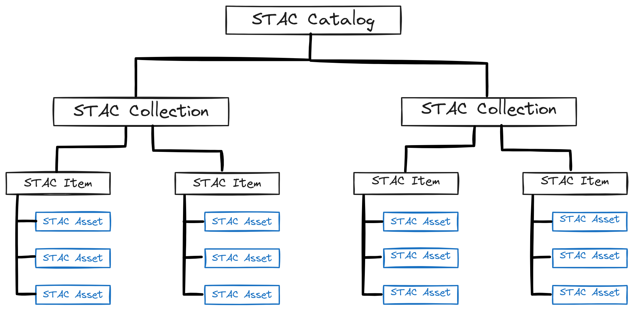
Let us now explore in more detail the individual components:
Catalog
A Catalog serves as the initial entry point of a STAC. A catalog is a very simple construct; it simply provides links to Collections or Items. The closest analogue is a folder on your computer. A Catalog can be a folder for Items, but it can also be a folder for Collections or other Catalogs. When searching for specific data, you first establish a connection to a valid STAC catalog.
Collection
Collections are containers that support the grouping of Items. The Collection entity shares most fields with the Catalog entity but has several additional fields, such as license, extent (spatial and temporal), providers, keywords and summaries. Every Item in a Collection links back to its Collection. Collection is often used to provide additional structure in a STAC catalog.
But when to use a Collection versus a Catalog? A Collection generally consists of a set of assets that share the same properties and share higher-level metadata. For example, data from the same satellite sensor or constellation would typically be in one Collection.
Catalogs, in turn, are used to split overly large Collections into groups and to group collections into a catalog of Collections (e.g. as an entry point for navigation to several Collections).
It is recommended to use Collections for what you want users to find and Catalogs for structuring and grouping Collections.
Item
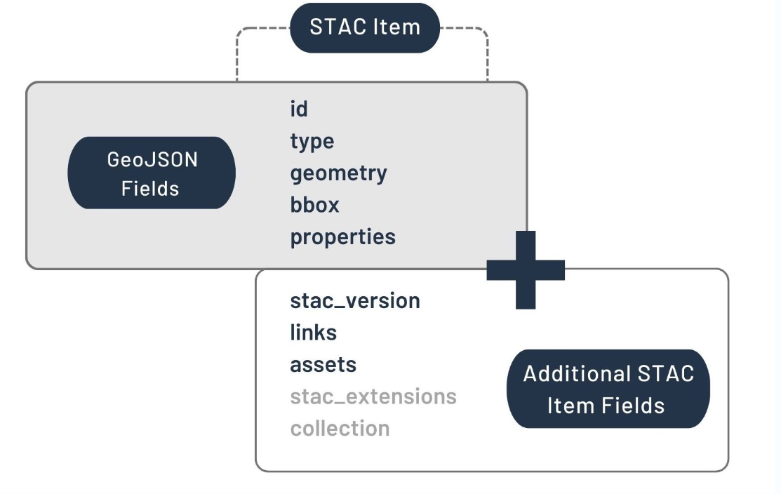
An Item is the fundamental element of STAC and typically represents a single scene at one place and time. It is a GeoJSON supplemented with additional metadata, which serves as an index to Assets.
Asset
An Asset is the smallest element inside a STAC and represents the individual data file that is linked in a STAC Item.
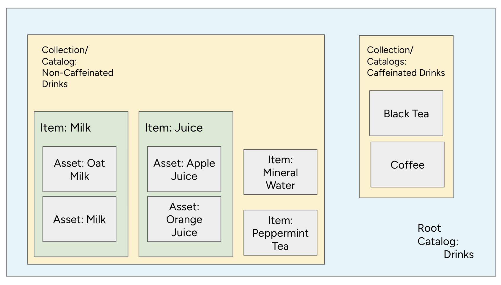
Analogy: Organising a drinks menu as a STAC
To better understand the relation of STAC components, let us imagine a Drinks menu as a STAC. How would you structure Drinks as a STAC?
Let us start with the Drinks category itself. The menu is analogous to a STAC Catalog, as it serves as the top-level entry point, providing an overview of all beverages available.
Within this Drinks catalog, we can group the Drinks further in There are hot and cold beverages, caffeinated and non-caffeinated drinks. These categories represent Collections in STAC.
For our analogy, let us say the menu is divided into two main collections:
- Caffeinated Drinks Collection: This section groups all beverages that contain caffeine.
- Non-Caffeinated Drinks Collection: This section groups all beverages that do not contain caffeine.
Each of these collections contains specific drinks, which are analogous to STAC Items. Drink Items could be, e.g. Juices or Milks. Both represent again a group of specific juices and milks, which are analogous to Assets in STAC. For the Drink Items defined, theirAssets` might include:
| Item | Assets |
|---|---|
| Milks | Oat Milk Regular Milk |
| Juices | Apple Juice Organge Juice … |
The STAC structure allows us to easily navigate a vast amount of data, just as a well-organised menu helps a customer quickly find their desired drink.
Conclusion
In this section, you got an introduction to the Spatio-Temporal Asset Catalog (STAC) and learned what STAC is and explored the main components of a STAC. Understanding the distinction between Catalog, Collection, Items and Assets is important to effectively navigating through STAC APIs.
What’s next?
In the following section, we will explore the web interface of the EOPF Sentinel Zarr Samples Service STAC Catalog.