Access EOPF Zarr in QGIS Using STAC
Introduction
The following page will demonstrate how to access the EOPF STAC Catalog in QGIS. We will utilise QGIS’s native STAC capabilities to add Sentinel-2 L2A Zarr items delivered from EOPF STAC Catalog to a QGIS project.
What We Will Learn
- 🔗 Connect QGIS to EOPF STAC,
- 🔍 Discover EOPF Zarr data, and
- 🌍 Visualise EOPF Zarr data as part of a map
Prerequisites
Some of the following steps are not possible with the latest QGIS release at the time of writing (3.44). QGIS 4.0 is expected February 2026 and will include all required functionality. Before then you must either install an experimental weekly or nightly build, or build the application yourself from source.
This document covers areas that are in development and may change over the coming months and years. New versions of QGIS and changes to EOPF Zarr metadata may alter requirements or workflows.
About STAC in QGIS
QGIS users may already be familiar with the STAC API Browser plugin. Since its release in 2022 this plugin provided basic STAC API support. However, since QGIS 3.40 (released October 2024) STAC support has been steadily growing within the QGIS core product. QGIS STAC users are advised to use QGIS core STAC functionality rather than the plugin.
When new to STAC, we suggest having a look at the Introduction to STAC chapter for more information about STAC and its components.
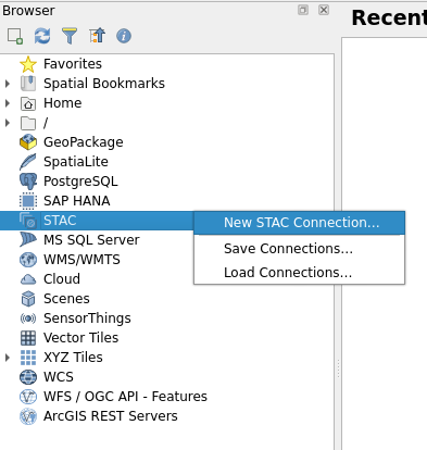
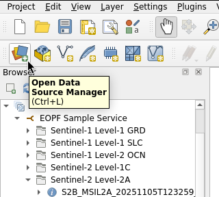
Add STAC Connection
STAC access in QGIS is managed with connections, similar to other remote data sources such as WMS, WFS, and ArcGIS REST Servers. A STAC connection can be created by right-clicking on the Browser pane’s STAC entry.
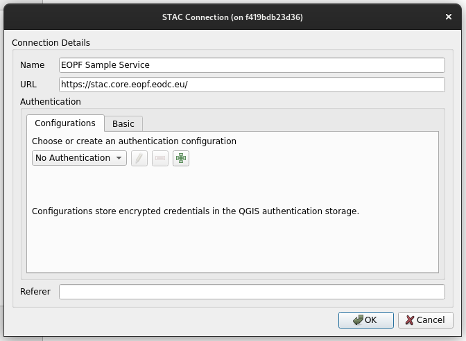
To identify the connection, we suggest providing a suitable name, such as EOPF Sample Service, and https://stac.core.eopf.eodc.eu/ for the service’s URL. Until now, this service does not require authentication, but we suggest following the ongoing discussions on the EOPF forum to keep track of EOPF’s STAC Catalog updates.
Discover Data
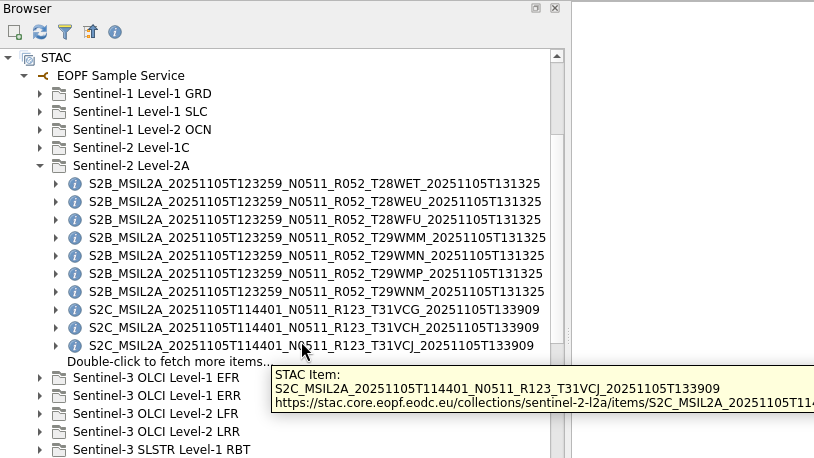
Once connected, we can expand the new connection to explore available STAC collections and STAC items. Each entry provides a tooltip on mouse-over.
The Browser pane’s nested view shows a limited number of STAC items, as they are ordered in the collection. Additional batches of items will be fetched if available when Double-click to fetch more items... is double-clicked. The STAC items can also be filtered in the Data Source Manager, which is discussed further in Data Source Manager, though this is not possible in the Browser pane.
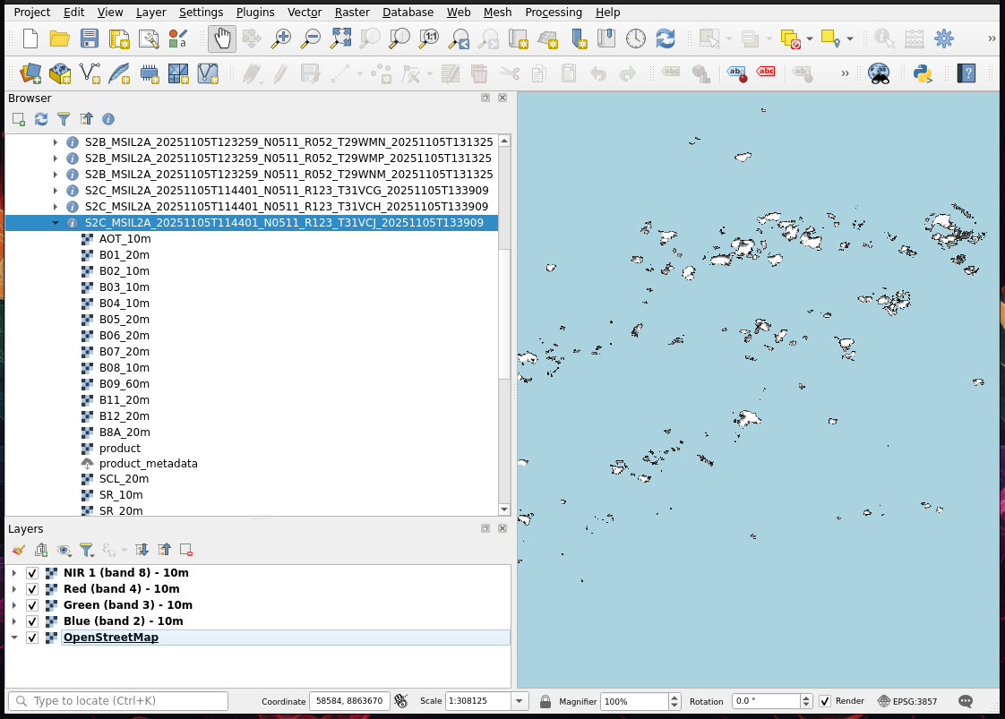
Add Data to a Project
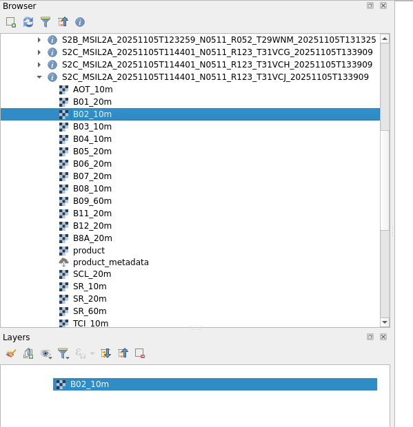
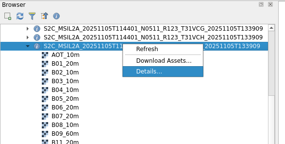
Once we expand a STAC item in the Browser pane, all assets associated with the item are listed.
Assets with cloud-optimised data types like Zarr, COG, COPC, etc., can be added as project layers from the Browser pane. These assets’ icons reflect their data type, such as the raster icon  . Assets that are not cloud-optimised (GeoJSON, GeoPackage, Shapefile, etc.) must first be downloaded before they can be added as project layers using QGIS’s standard Layer → Add Layer menu. These assets will have a download icon
  .
.
Remember: Cloud-optimised assets cannot be downloaded.
Cloud-optimised assets can be dragged from the Browser pane into the Layers pane. STAC items with one or more cloud-optimised assets can also be dragged into the Layers pane, which will add all cloud-optimised assets as layers.
Correct Spatial Reference
Due to differences in how EOPF, GDAL and QGIS define spatial references in the Zarr format, QGIS is not able to automatically recognise an EOPF Zarr layer’s spatial reference (CRS). This may be fixed by a future release of either QGIS or by the EOPF Zarr format structure. For now, we can solve this issue by manually correcting the spatial reference.
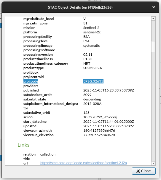
EOPF STAC item metadata provides the EPSG code that georeferences all of the item’s assets. We can access this metadata via the Details entry in the item’s context menu.
Then, we scroll down to the proj:code property and observe the EPSG:-prefixed numeric value.
After closing the Details window, we open one of our Zarr layers’ Properties window, and click on the Source tab. Under Assigned Coordinate Reference System (CRS) we will see “invalid projection” in the dropdown.
If while following these steps, the EPSG code from the STAC item Details window is already assigned, the issue has been resolved and we can skip this step.
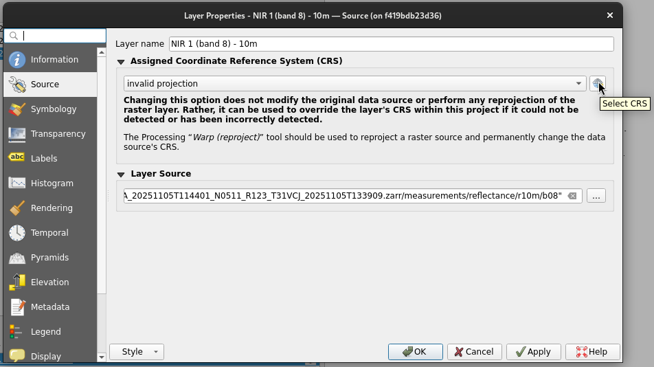
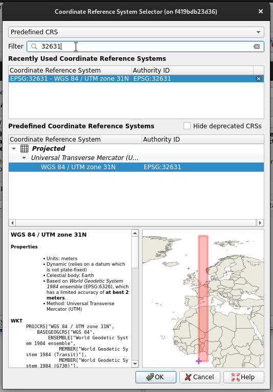
To correct the metadata for a smooth integration in QGIS, we can click “Select CRS” and type the STAC item’s EPSG code in the Filter text box. We then select the appropriate CRS entry and apply the change.
View Data
After correcting any invalid CRS configurations we will safely view EOPF Zarr data alongside other spatially referenced data.
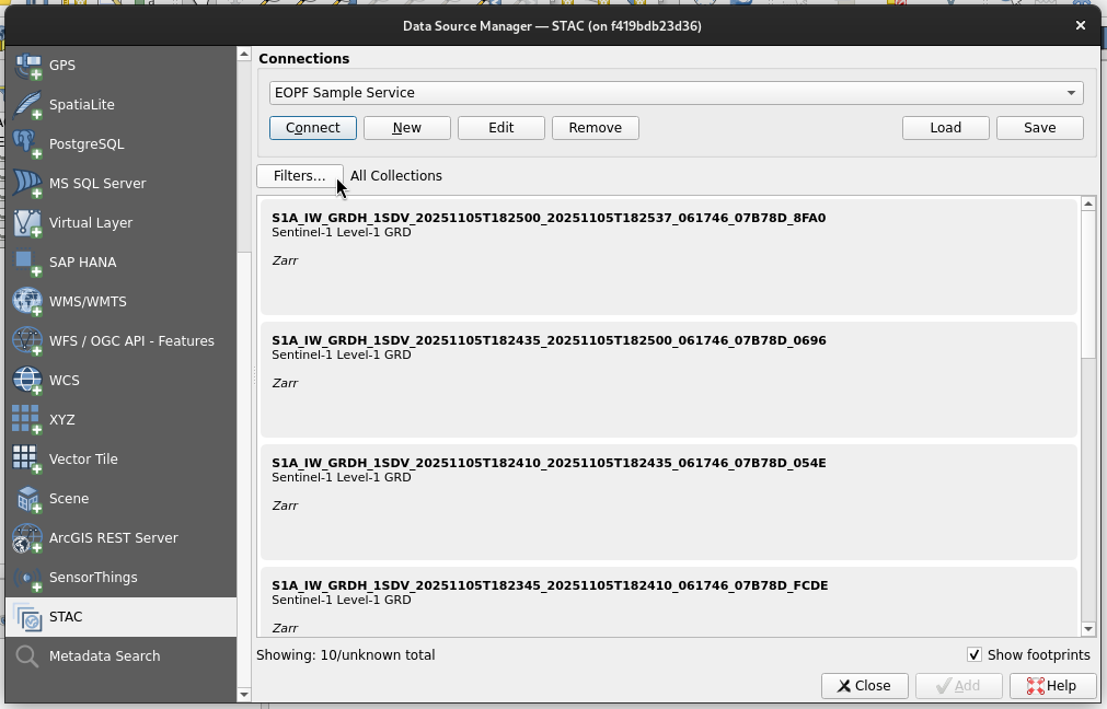
Data Source Manager
QGIS’s Data Source Manager can be used instead of the Browser pane to manage STAC connections and discover STAC data.
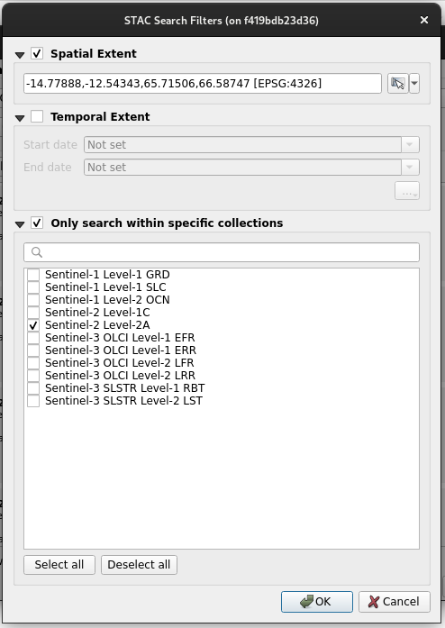
The Data Source Manager supports basic filters to refine which STAC items are available for access.
In the following example a bounding box filter is applied to items within a single collection. The format of the bounding box needs to follow:
minimum x (longitude), maximum x, minimum y (latitude), maximum y [EPSG:4326]We can also temporally filter a STAC connection via a calendar-style date picker.
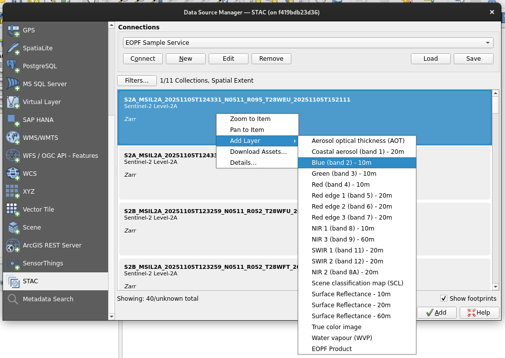
Once we right-click a search result, we can see the available actions we can follow, which include the Add Layer nested menu. This menu includes all cloud-optimised assets inside the item. Selecting an asset here is equivalent to dragging the asset to the Layers pane as described in the Add Data to a Project section.
💪 Now it is your turn
Task 1: Discover Additional Layers
- Add a STAC item’s
EOPF Productgroup asset to a QGIS project from either the Browser pane or the Data Source Manager - Review the arrays available within this group, noting that many are not published as STAC item assets
- Add arrays as layers to the QGIS project
Task 2: Apply Temporal Filters
- Apply filters in the Data Source Manager STAC tab using the calendar-style date picker
- Note that STAC items are filtered according to their
datetimeproperty, whose partial value also appears in the item’s ID - Add layers from a STAC item that was created yesterday
Conclusion
This tutorial demonstrated how to integrate and visualise EOPF Zarr items in QGIS using STAC. We also offered a work-around to the current CRS issue and explored EOPF Zarr data.
What’s next?
In the following section we will present several end-to-end workflows, where we will showcase the application of the available Sentinel Products in the EOPF Sentinel Zarr Sample Service STAC Catalog.